The
Tower, Lamar, Yellowstone River and Northeast Entrance area provides
a diverse terrain for hikers. This area possesses sheer mountain slopes
with banded cliffs, broad, open valleys and deeply etched river canyons.
The lower elevations along the Yellowstone
River provide hikers with snow-free, early spring access, but mountain
passes along the Absaroka Range area remain snow-covered until mid to
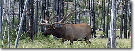
late July. Wildlife use the extremes of this region too. The valleys,
like Lamar and the lower Yellowstone Valley, provide mild winter grounds
for big-game animals, including elk, mule deer, bighorn sheep and mountain
lions. Then, in summer, the high pastures, meadows and mountain summits
provide haven and sanctuary from summer heat and insects.
Most of the Tower-Northeast Entrance
trails will show signs of the 1988 fires. This region burned extensively
that summer, and the rejuvenation is visible in varying degrees along
most trails. The trees within the burned forests remained.
Yellowstone River Trail
Length to Gardiner, Montana from:
Hellroaring Gravel Pit Trailhead 16.75 miles, one way.
Hellroaring Ford 14.75 miles, one way.
Cottonwood Creek 11.1 miles, one way.
Blacktail Bridge 7.75 miles, one way.
Crevice Creek Bridge 6.7 miles, one way.
Bear Creek Bridge 1.75 miles, one way.
Elevation change: Blacktail/Gravel Pit Trailhead at 6,520 feet (1,252-foot
loss).
Trailhead: The trailhead begins at the Hellroaring/Gravel Pit parking
area, 3.4 miles west of Tower Junction on the Mammoth-Tower Road, just
beyond Floating Island Lake.
The Yellowstone River Trail is one of
the longest trails in the northern section of the park, and most hikers
who take on this trail do so as a two-day trip. It also has the distinction
of having the lowest elevation of any trail in the park. For this reason,
it can be hiked early in the season when most trails are still buried
under snow. The only drawback of an early spring hike is the spring
runoff. Many of the Yellowstone River's tributaries, including the river
itself, usually are swollen and treacherous to cross or ford. Several
creeks along this stretch, including Hellroaring, Little Cottonwood,
Cotton-wood, Crevice (footbridge) and Bear (footbridge), can be very
dangerous. At Hellroaring, the beginning of the Yellowstone River
Trail, a crossing is provided 0.8 miles upstream. The bridge adds a
few extra miles, but safety is a factor.
The Yellowstone River Trail is accessed
by the Hellroaring/ Gravel Pit Trailhead. The Hellroaring Creek Trail
(see Hellroaring Creek Trail for description) leads to Hellroaring Ford
and the beginning of this trail. After either fording the stream (only
late in the season when the water level is down and it is safe to cross)
or by using the bridge upstream, the Yellowstone River Trail begins
its descent along the river to Gardiner, Montana.
The flora and fauna is entirely different
along this trail than it is along the higher trails in the interior
of the park. A few large Douglas fir trees are common, but most are
Rocky Mountain junipers. In late July or August, check the trunks of
these trees for shells or skins of cicadas. These large insects spent
most of their lives as grubs underground, feeding on the roots of the
tree. They then emerge and begin their metamorphosis into membranous
winged adults. During the summer, you will hear their shrill droning
sound, which is produced by specialized organs.
This area also is a refuge for wintering
big-game animals, including mule deer, elk, bighorn sheep and predators
such as the mountain lion and coyote. Even during the summer, there
are telltale signs of their presence. Droppings, patches of shed winter
coat, dropped antlers and overgrazed vegetation all are signs of their
stay.
Most of the valley forms a tight gorge
with fairly steep walls beginning at Cottonwood Creek. This is known
as the Black Canyon because of the darkness produced by the close canyon
walls. Cottonwood Creek is a popular campsite and a good first-day hike.
Little Cottonwood Creek also is a good campsite, with a spring nearby.
But use a water filter before drinking any water, and make sure you
have plenty of good drinking water for this journey.
The Blacktail Deer Creek Trail (see Blacktail
Deer Creek River Trail,for description) joins the Yellowstone River
Trail at the suspension bridge and at the 9.0-mile marker. The river
can be exited from this point, but it is a 1,078-foot, 3.4-mile climb
to the Blacktail Trailhead.
The next landmarks are Crevice Creek
and just beyond Knowles Falls, at the 10.75-mile mark. Do not expect
another Lower Falls. The river is constricted through rock formations
and only produces a 15-foot plunge. Even so, the force and power is
impressive. From Knowles Falls,
the landscape becomes even more desert-like, and the possibility of
seeing snakes increases. Bull and garter snakes are common, and it is
possible-though not highly probable-to find a rattlesnake, so take precaution
when hiking this trail. The trail
emerges at Gardiner, just north of the Yellow-stone Bridge in the downtown
area.
Lost Lake-Petrified Tree Trail
Length: 3.1 miles, loop via Lost Lake and Petrified Tree.
Length from Roosevelt Lodge to:
Lost Creek Falls (spur trail) 0.25 miles
Lost Lake 0.8 miles
Petrified Tree 1.8 miles
Tower Ranger Station (via Petrified Tree) 2.7 miles
Elevation change: Trailhead at 6,340 (460-foot gain).
Trailhead: The trail starts behind Roosevelt Lodge. Or, as an alternate
route, start at the Petrified Tree, about a quarter mile east of the
Blacktail Plateau Drive exit or about 1.4 miles west of Tower Junction.
The trail begins directly behind Roosevelt
Lodge. It crosses a footbridge and over a wet seep shrouded with ferns.
From there a short spur trail leads
to Lost Creek Falls, a 40-foot plunge into a steep, dark, timber-covered
canyon. From the junction to Lost Creek Falls, the trail climbs south
up a steep 350-foot rocky rim. On the bench above the rim, the trail
then joins the horse trail and continues west to Lost Lake and Petrified
Tree. The trail east heads to Roosevelt Corral and approximately 2.5
miles to Tower Campground (see Roosevelt-Tower Trail for description).
In 1975, an earthquake with an epicenter
near Norris Geyser Basin shook the Yellowstone region. It brought down
delicate spires in the Grand Canyon, and along this rim, large rockfalls
tumbled down the canyon, nearly striking passing hikers.
The trail continues along the shore of
Lost Lake, where beaver activity usually can be spotted. In late June
through early July, the edges of this lake are covered with the arrow-shaped,
leather-like leaves and yellow, baseball-sized flowers of yellow pond
lilies. The trail follows the drainage of Lost Lake through Douglas
fir and aspen, and emerges at the Petrified Tree parking area.
The Petrified Tree has a substantial
iron fence that was installed in 1907 for its protection. At one time,
there were several trees in the vicinity, with broken remnants scattered
on the hillside, but collection and souvenir hunters removed these piece
by piece, including a whole fossilized tree. The remaining tree is a
siliceous replica-a fossil-of an ancient redwood. To
continue back to Roosevelt Lodge, the trail climbs the hill at the northeast
end of the parking area. (For winter skiing, the short spur road to
Petrified Tree is unplowed, and access to this trail and parking is
at the turnout on the Mammoth-Tower Road.) From the parking area, this
trail leads over the saddle between two hills and behind the Tower Ranger
Station and through the Park Service employee-housing area to the cabins
at Roosevelt Lodge. The trail emerges at Hamilton General Store.
Roosevelt-Tower Trail
Length from Roosevelt Lodge to:
Lost Creek Falls (spur trail) 0.25 miles
Tower Fall Campground 2.6 miles
Elevation change: Trailhead at 6,340 (350-foot gain, but overall, a
258-foot gain). Trailhead: The trail begins behind Roosevelt Lodge.
The trail starts directly behind Roosevelt
Lodge, and it is a good half-day hike for residents staying at the lodge
or at Tower Campground. The trail crosses a footbridge over a wet seep
that is covered in ferns. From there, a short spur trail leads to Lost
Creek Falls, a 40-foot plunge over a basalt cliff into a steep, dark,
timber-covered canyon. From the junction to the top of the cliffs is
a steep 350-foot climb. On the bench above the rim, the trail then junctions
with the horse trail. The area east of Roosevelt is crisscrossed with
horse trails; be careful not to return to the Roosevelt corral via one
of these shortcut horse trails. The west trail leads to Lost Lake (see
Lost Lake Trail for description) and farther beyond to Petrified Tree.
The east trail leads to Tower Campground. The
trail continues east through Douglas firs, small open meadows and undulating
terrain. During summer, this is a very dry trail. About halfway, the
trail parallels the road, but the trail is on the cliff above it before
eventually emerging at Tower Campground.
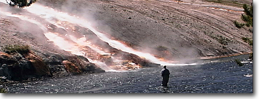
Calcite Springs Overlook Trail
Length: .1 miles, loop
Elevation change: Trailhead at 6,400 feet. ^No substantial elevation
change.) Trailhead: Located 0.7
miles northwest of Tower Falls, or 1.7 miles southeast of Tower Junction.
This is a short, easy, loop walk that
leads to a platform overlooking the Yellowstone River, which also views
remarkable-almost man-made-looking-layers of basalt columns, and thermal
springs along the rivers edge. The
area was named by USGS geologist Arnold Hague in 1885, but this name
was based on previous usage. The constriction in the river also is called
"The Narrows." Early explorers discovered the "sulphur"
to be "pure enough to burn readily when ignited." Research
conducted during the 1930s found the springs to have the highest percentage
of hydrogen sulfide gas-that rotten-egg smell associated with sulphur
springs- as well as deposits of calcite and gypsum. Calcite Springs
is the lowest elevation of any hot area in the park.
The east wall of the Grand Canyon, facing
the overlook, is a cross-section of layers of glacial drift resting
on lake deposits and columnar basalt. The pentagonal columns of basalt
are caused by cooling, shrinking and cracking of several basaltic flows.
Tower Falls Trail
Length: 0.4 miles, one way. Elevation
change: Trailhead at 6,440 feet (240-foot loss). Trailhead: The trailhead
is located at the parking area for Tower Falls and the Tower Store.
This popular waterfall on Tower Creek
was named by members of the 1870 Washburn expedition. It first was called "Minaret Creek," but one member
objected, stating that the name violated their agreement to naming objects
for their friends. He claimed the name was in reference to "Minnie
Rhett," a sweetheart of one of the other members. By unanimous
vote, the name was reconsidered and the names "Tower Creek"
and "Tower Falls" were applied.
The trail begins at the falls overlook
and starts a steep descent into the river gorge. It is a narrow trail,
and a series of switchbacks descends 200 feet to the bottom. Once at
the bottom, the Yellowstone River is accessible by leaving the trail
and walking out onto a gravel bar. But by continuing along the trail
up Tower Creek, especially on a hot summer day, the humidity rises and
the temperature drops as you reach the base of Tower Falls. The falls
produces its own microclimate, a relief on hot summer days.
The 132-foot falls plunges as a near-perfect
water column until it crashes onto the rocks at its base. Until 1986,
a precarious boulder was perched on the lip of the falls, and in the
spring of that year, without witnesses, it, too, plunged to the bottom.
Tower Creek has cut through the basalt formation, making up the walls
of the gorge. At the brink of the falls are eerie-shaped minarets or
towers sculpted from rhyolitic basalt.
Tower Falls also is a popular destination
for cross-country skiing. The road from Tower Junction to Tower Falls
is, however, closed to car travel. But the 2.3-mile road from Tower
Junction can be skied to the overlook if it is an ample snow year. It
is not recommended to ski or hike to the base. Because it is a north-facing
slope, ice builds up on the trails, and with its steep slope, the trail
becomes treacherous.
Tower Creek Trail
Length: 4 miles, one way, to Carnelian
Creek.
Elevation change: Trailhead at 6,598 feet (402-foot gain).
Trailhead: Located at the entrance to Tower Campground.
This trail is an excellent short hike
for guests staying at the Tower Campground. The trail provides access
for fishermen and a pleasant evening stroll. Tower Creek tumbles among
boulders through a lush canyon during its descent, before reaching the
towers of Tower Falls. The trail stretches about 4 miles, to where Tower
and Carnelian creeks merge. This region did, however, burn during the
1988 fires.
Yellowstone River Picnic Area Trail
Length from Yellowstone River picnic area to:
Calcite Springs View 1.0 miles, one way.
Four-way junction 2.0 miles, one way.
Bannock Ford (spur trail) 2.4 miles, one way. Return to picnic area
4.0-mile loop. Elevation change: Trailhead at 6,200 feet (414-foot gain
to The Narrows viewing area).
Trailhead: Located at the Yellowstone River picnic area, a mile north
of Tower Junction on the Northeast Entrance Road.
This trail is a short easy hike and provides
wonderful views of Calcite Springs, the narrows of the Yellowstone,
the Overhanging Cliff, the towers of Tower Falls, the basalt columns
and the historic Bannock Indian Ford. It also offers views of the Tower
General Store and the Tower-Canyon Road, and provides access to the
Specimen Ridge Trail (see Specimen Ridge Trail for description) above
the Bannock Ford. From the picnic
area, the trail heads south and parallels the Yellowstone River. The
trail runs very close along the river canyon, and drop offs are common
near the trail. Take precautions while hiking this stretch of the trail.
Bighorn sheep occasionally are spotted
in this area during early spring and fall, as they migrate to and from
the high country in the Washburn area. The primary trees along the rim
are Douglas fir, limber pine and Rocky Mountain juniper.
The trail meets a four-way junction,
the southern trail leads to the Bannock Indian Ford. The eastern trail
leads to Specimen Ridge, a long, hot and grueling hike to the petrified
forest. The northern trail leads directly to the Northeast Entrance
Road and emerges at the glacier exhibit turnout. This is the continuing
trail for the loop hike, but it is not highly recommended because the
return route follows the road for the last mile. The recommended route
is to return on the same trail from the four-way junction. The Bannock
Indian Trail, branching south at the four-way junction, descends steeply
to the bottom of the Grand Canyon at Tower Falls. The Great Bannock
Trail crosses the Yellowstone at the point of a small island. Indians
used this ford during their migrations until the 1870s, at which time
early trappers and explorers began to use it. John Colter also is credited
with using the ford during his historic 1807-1808 winter trip through
Yellowstone, even though his exact route has never been known.
The trail meets a four-way junction,
the southern trail leads to the Bannock Indian Ford. The eastern trail
leads to Specimen Ridge, a long, hot and grueling hike to the petrified
forest. The northern trail leads directly to the Northeast Entrance
Road and emerges at the glacier exhibit turnout. This is the continuing
trail for the loop hike, but it is not highly recommended because the
return route follows the road for the last mile. The recommended route
is to return on the same trail from the four-way junction.
The Bannock Indian Trail, branching south
at the four-way junction, descends steeply to the bottom of the Grand
Canyon at Tower Falls. The Great Bannock Trail crosses the Yellowstone
at the point of a small island. Indians used this ford during their
migrations until the 1870s, at which time early trappers and explorers
began to use it. John Colter also is credited with using the ford during
his historic 1807-1808 winter trip through Yellowstone, even though
his exact route has never been known.
Specimen Ridge Trail
Length from Specimen Trailhead
to:
Four-way junction 1.0 miles one way.
Bannock Ford (spur trail) 1.4 miles, one way.
Specimen Ridge (fossil forest) 3.2 miles, one way.
Amethyst Mountain 10.0 miles, one way.
Lamar Valley Trail junction 14.7 miles, one way.
Soda Butte Trailhead 17.1 miles,
one way.
Elevation change: Trailhead at 6,250
feet (350-foot gain, but overall, a 3,364-foot gain to Amethyst Mountain).
Trailhead: The trailhead is 2.2 miles north, then east, of Tower Junction
on the Northeast Entrance Road, at the glacier exhibit.
The Specimen Ridge Trail is a long, hot
and grueling trail during summer. But it does provide access to unusual
features, terrain and valley vistas. A good portion of this trail, however,
shows signs of the 1988 fires. Winds pushed the fire here and it burned
the ridge extensively on most sides.
From the trailhead, the trail heads south
toward the Yellowstone River, where it arrives at the four-way junction.
The west trail leads to the Yellowstone River picnic area (see Yellowstone
River picnic area trail for description), and the south trail leads
to the old Bannock Indian Ford.
The east trail continues on the Specimen
Ridge Trail and begins a steep ascent of the ridge. Atop Specimen Ridge
is a spur trail to the Specimen Fossil Forest. This trail accesses the
Specimen Fossil Forest Trail (see Specimen Fossil Forest Trail for description)
and the petrified fossil trees on the north aspect of Specimen Ridge.
From the summit of Specimen Ridge, the
trail continues east through high, rolling hills. It is not an interesting
trail, but there are good views of Yellowstone-especially of the Grand
Canyon-from the high points.
Amethyst Mountain (9,614 feet) is the
highest point along the trail; from there is a good view of Mount Washburn
to the west and the Mirror Plateau to the southeast. From Amethyst Mountain,
the trail begins its 2,854-foot descent over 4.2 miles into the Lamar
Valley and the junction with the Lamar Valley Trail (see Lamar Valley
Trail for description). From the
Lamar Valley Trail, choose from two directions to approach the Northeast
Entrance Road. The longest route heads northwest down valley and ends
at the Lamar picnic area near the Lamar Ranger Station, but the Lamar
River must be forded just before the picnic area. The other route, the
shortest and most direct one, fords the Lamar River just after the Lamar
Valley Trail junction and continues northeast. The trail then crosses
Soda Butte Creek via a footbridge before exiting at Soda Butte Trailhead.
Specimen Fossil Forest Trail
Length: 1.4 miles, one way. Elevation change: Trailhead at 6,210 feet
(1,751-foot gain).
Trailhead: Located 4.75 miles east on the Northeast Entrance Road. A
pulloff is located to the south of the Lamar River Bridge, next to a
flat grassy area.
Two locations access the fossil forest.
The first access is 0.2 miles from the Lamar River Bridge. At that point
is an old road, faintly visible to the Crystal Creek elk trap, a V-shaped
trap used by the Park Service until the 1970s. Helicopters would force
the animals from the Lamar Valley, where they would be herded into the
V-trap and corralled. Some of the elk were loaded into stock trucks
and hauled to other locations outside of the park. Others were shot
and butchered, but most of them were shot and bulldozed into trenches.
When the public discovered this atrocity, the operations ceased, and
the corrals later were disassembled, the road rehabilitated, and any knowledge of its existence disavowed.
On the flat plain near Crystal Creek
are a series of stone alignments, or tepee rings, that probably are
several hundred years old. Several of the rings, however, were destroyed
by bulldozers during the elk-trapping operations. These constitute some
of the few stone alignments found in the park.
The trail from the elk trap follows the
ridge that parallels Crystal Creek to the fossil forest near the top
of the ridge. Mormon, or fossil, crickets line the trail in late July
or early August. The other trail
begins a mile before the bridge on the south side of the road. This
trail goes through a few boulders, then straight up the hill to a small
fossil tree. From there, the trail continues along the ridge, merging
with the Crystal Creek access, entering Douglas fir stands and emerging
at a rhyolitic outcropping and three large fossil trees, plus a few
stumps and downed trees. A large fossilized redwood tree has an exposed
root system that has been weathered and undercut on the downhill side.
The summit of Specimen Ridge (7,961 feet)
is easily reached by returning to the ridge trail. Bitterroots bloom
here in late May or early June. The view from the top includes vistas
of the lower Grand Canyon and the Tower Falls area to the south; Tower
Junction to the west; and the Lamar River, Slough Creek and their confluence
to the north.
The 1988 fires swept across the ridge
and burned trees, shrubs and grassland on the south-facing slope of
Specimen Ridge, but it spared patches of vegetation on the north face. For a longer hike, access the east-west
Specimen Ridge Trail (see Specimen Ridge Trail for description) from
the summit.
Lamar Valley Trail
Length: 5.3 miles, one way.
Elevation change: Trailhead at 6,600 feet (80-foot drop).
Trailhead: The Soda Butte Trailhead is on the Northeast Entrance Road,
between Tower and Cooke City, about 10.75 miles east of Tower Junction,
or 4.0 miles east of the Lamar Ranger Station.
Two trailheads exist for this valley
hike. Both are within a quarter mile of each other, but the first is
2.8 miles from Lamar Ranger Station.
This trailhead is not recommended for hikers because it generally is
used by horse packers accessing the upper Lamar region and the Absaroka
(pronounced Ab-sore-ka) Range. Horses crossing Soda Butte Creek have
no difficulty but hikers will get their feet wet. About a mile and a
quarter east is the hikers' access. This trail crosses a wooden bridge
and continues south along the eastern edge of the Lamar Valley, at the
base of Mount Norris. The trail is relatively flat, exposed, and cuts
through sagebrush and bunchgrasses. Just
before the trail climbs a steep bench or terrace, the horse trail
joins the hikers' trail. Then, at the base of the bench, the trail junction
for Upper Lamar-including Cache, Calfee and Miller creeks-splits to
the east, and heads up-valley.
The Lamar Valley Trail fords the Lamar
River toward the base of Amethyst Mountain (9,614 feet) and the start
of the Specimen Ridge Trail (see Specimen Ridge Trail for description).
This is a major river ford, so spring or early summer crossing, when
the river is in full force, is not recommended. By late summer and fall,
the river is down, but it still can be treacherous to cross. The cobble
river bottom is uneven and slippery- old sneakers are the best footwear
for fording here. After climbing
the river bank, the trail is well-marked for the Specimen Ridge Trail,
but the Lamar Valley Trail is very faint. Game trails crisscross the
Lamar Valley, and the best plan is to follow worn trails and maintain
a sense of direction by paralleling the Lamar river and valley.
The Lamar Valley Trail provides one of
the best opportunities to walk among and view wildlife in the park.
The steep, forested slope on the southern edge of the valley harbors
elk and bison during the day. They move in and out of the forest, spending
most of their nights in the open, unprotected valley. Visible along
the forest edge are veins and arteries of game trails leading
to and from the forest and valley. Coyotes also wander along the trails
looking for an opportunistic meal.
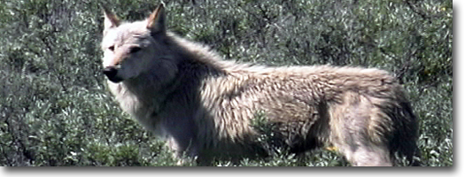
In the winter of 1995, Canada gray wolves,
primarily black in color, were introduced into Yellowstone and were
released into the Lamar Valley. Several holding pens were built along
the valley, out of the public's view, and the wolves were released that
spring. Some wolves immediately left the park, while others discovered
the advantage of being in the Lamar Valley during elk calving season.
Many visitors were able to view the drama of wolves bringing down and
disemboweling one or two elk calves a day. If the wolves remain, it
will take several years to determine what effect this experiment will
have on elk and bison populations. Coyotes have been a major character
of the Lamar, but their status certainly will change and they will be
displaced.
The openness of the Lamar Valley is its
uniqueness. To look up and down the valley while hiking and to realize
the vast distance to cover by foot is humbling.
Near the trails' end, you can see a clump
of cottonwoods at a distance. The cottonwood clump shelters the Lamar
picnic area. Just before the picnic area is another river ford. This
ford is, however, twice as treacherous, since both the Lamar River and
Soda Butte Creek merge up-river. Scout for a shallow area to cross,
and make sure your pack straps and buckles are unsnapped.
Slough Creek Trail
Length from Slough Creek Campground to: Buffalo Plateau Trail junction
1.6 miles, one way. Elevation change: Trailhead at 6,251 feet (399-foot
gain).
Trailhead: Located at the entrance to Slough Creek Camp-ground, 1.6
miles down the gravel road north of the Northeast Entrance Road.
Slough Creek is a Shangri-la-like valley,
where life seems to slow down to match the rhythm of the river. Early
trappers, including Osborne Russell and Jim Bridger, trapped at this stream as early as the 1830s. But it was
not until the 1860s that a prospecting party venturing up the Yellowstone
River named the stream. One member, Ansel Hubble, while on reconnaissance,
discovered the creek. When his fellow members asked what type of stream
was up ahead, he replied, "Twas but a slough."
Slough Creek is a popular fishing destination,
even though all fishing in the drainage is catch-and-release. The stream
is well-known for its cutthroat trout, and heavy stocking was accomplished
between the 1920s and 1950s. Longnose dace and longnose suckers also
inhabit the creek. Other than fish, the valley is not well-known for
its wildlife. Grizzly bear do, however, frequent the area, especially
in early spring and late fall. The only other critters of which to be
wary are mosquitoes. Clouds of mosquitoes are very common during moist
summers, and this valley ranks as one of the worst for the pesky insects.
For the first couple of miles, the trail
climbs gradually through a Douglas fir forest until the trail descends
into a wide, grassy meadow and to the banks of Slough Creek. At this
point. Slough Creek is constricted by the damlike rocky escarpment.
Also at this point are the Slough Creek patrol cabins, and just beyond
them, the trail junctions. The Buffalo Plateau Trail (see Buffalo Plateau
Trail for description) intersects here in a north-south direction. To
reach McBride Lake, the north Buffalo Plateau Trail fords the creek
and heads about a mile east, via route-finding and bushwhacking, to
the lake. Slough Creek can be a dangerous stream to ford early before
mid-July. Use wise judgment before deciding to ford.
From the junction, the Slough Creek Trail
continues east. The trail actually is a two-track road. At the upper
end of Slough Creek, outside the park boundary, is the Silver Tip Ranch.
Summer residents of the old ranch haul supplies by horsedrawn wagons, which form the ruts. Just after
the junction, the trail diverges from the creek and climbs a ridge.
After descending the ridge, the trail enters another open meadow and
rejoins the creek at the Bliss Pass Trail junction.
Bliss Pass Trail climbs a steep continuous
uphill-gaming 2,573 feet-to Bliss Pass and descends into Pebble Creek
(see Pebble Creek Trail for description). The
Slough Creek Trail continues north for about three more miles to the
park boundary, and another tenth of a mile beyond that to Silver Tip
Ranch.
Trout Lake
Length: 0.5 miles, one way.
Elevation change: Trailhead at 6,800 feet (ISO-foot gain).
Trailhead: The trailhead is located on the west side of the Northeast
Entrance highway, about 1.3 miles south of Pebble Creek Campground or
17.5 miles northeast of Tower Junction, The trailhead is unmarked, but
there is a vehicle turnout.
Trout Lake is known for its excellent
fishing, but also is a great short hike. The
trail begins from the turnout and immediately begins a steep climb,
with switchbacks, over a small ridge covered with Douglas fir and lodgepole
pine. At the top of the ridge is a large Douglas fir and the first view
of Trout Lake. At the outlet is an eight- to nine-foot dam constructed
between 1919 and 1950 when Trout Lake, then known as Fish Lake, operated
as a fish hatchery. Originally, cutthroat trout were spawned here but,
by 1934, rainbow trout were planted to provide eggs for other park lakes.
By the early 1940s, rainbow-cutthroat hybrids were discovered, and the
lake was opened for fishing in 1994. The
lake water is clear and only 17 feet at its deepest, but dense aquatic
vegetation grows around the edge, making it difficult to catch the large
trout that abound here. Ducks also prefer this shallow lake, rich in
aquatic food. A perimeter trail crosses the outlet and also leads to
Buck and Shrimp lakes which contain few, if any, fish. From
Trout Lake are great views of The Thunderer (10,554 feet) to the east,
past open meadows to Mt. Hornaday (10,036 feet) to the north and Druid
Peak (9,583 feet) to the west, just beyond the immediate rocky cliff.
|