The
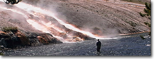
Norris area is another land of extremes. Norris Geyser Basin, named
after an early superintendent, may be the hottest basin in Yellowstone.
In 1929, the Carnegie Institute of Washington, D.C. made numerous test
wells to determine subsurface temperatures. One test hole was abandoned
at 265 feet when the temperature reached 401 degrees Fahrenheit and
the steam pressure threatened to destroy the drilling rig.
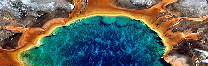
The terrain surrounding the basin is
the result of an acidic environment. Because of this extreme condition,
plants, algae and bacteria have difficulty establishing. Instead, the
basin derives its colors from mineral oxides, in spectrums of pink,
red, orange (iron oxides), and yellow (sulfur and iron sulfates). Near this hostile environment, in the
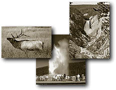
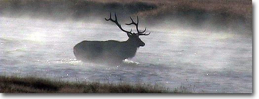
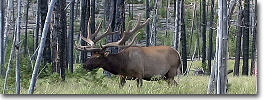
meadows along the Gibbon River, elk graze contentedly. Amidst this setting,
trails radiate into the surrounding area to explore small lakes, mountaintop
lockouts, mud-pot collections, and geyser basins with bizarre and unusual
features.
Three trails start from Norris Campground.
The first trail leads to Norris Geyser Basin. The second leads along
Solfatara Creek and wanders through meadows spotted by sulphur thermal
springs. And another leads to Ice Lake and farther along to Wolf Lake,
both popular fishing destinations. But even though they have been heavily
stocked with fish in the past, they now are relatively barren and provide
poor fishing opportunities. The lakes are, however, the headwaters of
the Gibbon River.
Ice Lake Trail
Length from Ice Lake Trailhead to:
Ice Lake - 0.3 miles, one way
Wolf Lake - 4.0 miles, one way
Elevation change: Trailhead at 7,800 feet (80-foot gain).
Trailhead: The trailhead is 3.25 miles east of Norris Junction on the
Norris Canyon Road, and the parking area is an unmarked turnout near
the exit of the Virginia Cascades road.
The trail is relatively flat and very
short, only a 10- to 15-minute hike from the trailhead. The lake itself
is lined with subalpine fir and lodgepole pine, but the 1988 fires have
affected some areas. Another approach
to Ice Lake is via the Norris Campground trail, which is about 4.3 miles.
The trail-head is located in the east central edge of the campground.
After about a half mile the trail
junctions and the southern trail crosses Solfatara Creek, then continues
through lodgepole pines, and a meadow before reaching the north side
of Ice Lake. Ice Lake and nearby Wolf and Grebe lakes are the headwaters
of the Gibbon River, which flows past Norris Geyser Basin and merges
with the Madison River at Madison Junction. Ice Lake is fed by underground
springs and seepage. Fish have been unable to establish in the lake,
even though massive stocking efforts between 1905 and 1961 released
nearly 4 million graying, brook trout, cutthroat trout and rainbow trout.
Because there is not a constant flowing inlet and outlet, conditions
are poor for spawning, leaving the lake barren offish.
During winter, the 224-acre lake freezes
over, but not solid. Only the first one to two feet of the 53-foot deep
lake freezes; on top of that, four to six feet of snow can accumulate,
making the lake appear as a large white field. It was named Ice Lake
circa 1900 because nearby Norris Hotel cut its ice supply from this
small lake.
On the northwest side of the lake the
trail joins the Howard Eaton Trail and continues east to Wolf and Grebe
lakes. But the Gibbon River will need to be forded several times before
reaching Wolf Lake. This lake is smaller-just a quarter of the size
of Ice Lake-but maintains a good population of rainbow trout. They were
introduced, along with graying and cutthroat, during the 1920s and 30s.
The trout began to hybridize and, by 1969, only rainbow-trout characteristics
were found. The large, open, marshy
meadows bordering the northwest and southeast shores of Wolf Lake often
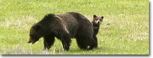
are occupied by moose, sandhill cranes (in the spring), or great blue
herons.
Norris Geyser Basin Trail
Length from Norris parking area to:
Porcelain Basin - 1.6-mile loop.
Back Basin - 2.0-mile loop.
Elevation change: Trailhead at 7,520 feet (40-foot gain).
Trailhead: Located at the Norris Geyser Basin parking area.
This is an exciting and easy hike into
an austere but colorful geyser basin. Two trails loop through the basin:
The northern loop explores Porcelain Basin; and the southern, longer
trail loops through the Back Basin.
Norris Geyser Basin was named after an
early Yellowstone superintendent, P.W. Norris, and this basin may be
the hottest geyser basin in Yellowstone. The Carnegie Institute of Washington,
D.C. made testwells in 1929 to determine subsurface temperatures. One
test hole was abandoned at 265 feet, when the temperature reached 401
°F and the steam pressure threatened to destroy the drilling rig.
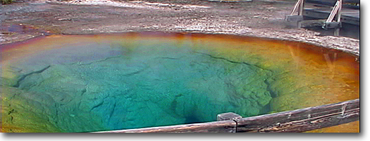
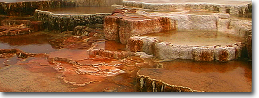
The stark, barren landscape of Porcelain
Basin is the result of an acidic environment. Because of this hostile
condition, plants, algae and bacteria have difficulty establishing themselves.
Instead, the basin derives its colors from mineral oxides, in spectrums
of pink, red, orange (iron oxides) and yellow (sulfur and iron sulfates). The acidic water also has created changes
in the formation of sinter deposited around vents. Silica deposits as
tiny, sharp spines instead of thick, beaded deposits common in more
alkaline basins.
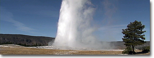
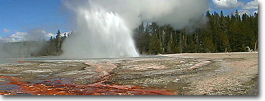
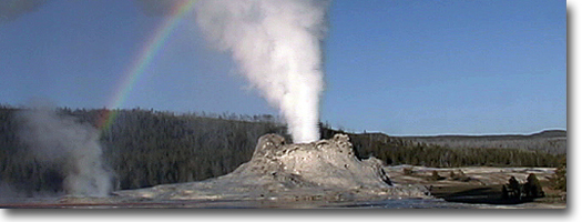
The Back Basin has the worlds largest
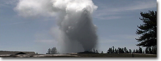
geyser, but plays at irregular intervals. Steamboat Geyser has long
periods of dormancy, but when it does erupt, it sends jets of water
nearly 380 feet high in a spectacular display. Echinus Geyser is the
largest predictable geyser at Norris. Before an eruption, water usually
fills the basin to within two or three feet of the rim and begins boiling.
Churning and splashing then trigger an eruption, throwing water and
steam upward in a series of explosive bursts. After an eruption, the
basin drains, producing a whirlpool and a gurgling that sounds as if
a stopper from a bathtub had been pulled.
Mt Holmes Trail
Length from Mt. Holmes Trailhead to:
Winter Creek - 1.0 miles, one way.
Junction with Grizzly Lake Trail - 2.3 miles, one way.
Junction with Trilobite Lake - 5.1 miles, one way.
Trilobite Lake (spur trail) - 7.3 miles, one way.
White Peaks/Mount Holmes Saddle - 9.1 miles, one way
Summit of Mount Holmes - 10.1 miles, one way.
Elevation change: Trailhead at 7,337 feet (2,999-foot gain). Trailhead:
The trailhead is located near Apollinaris Spring, 1.2 miles north of
Obsidian Cliff on the Mammoth-Norris Road, and is a small, poorly marked
pullout.
This is a long and strenuous day hike
and should be started early in the morning with intentions of returning
near or after dark. The summit of Mount Holmes generally is snow-covered
until late summer, and even then snow fields can still be found.
The start of this trail is the exit of
the Grizzly Lake Trail (see Grizzly Lake Trail for description). It
begins by passing a Park Service horse corral and following a power
line and old road for nearly a mile, at which point the trail treacherously
crosses Winter Creek on fallen logs. The trail continues through a sparse
lodgepole pine forest and junctions with the Grizzly Lake Trail after
about 2.3 miles.
The next landmark is a meadow, at about
6 miles, at the base of Mount Holmes. A side trail from here heads north
along a small drainage to Trilobite Lake, perched between Mount Holmes and Dome Mountain, and it is an
additional 2.2 miles, one way.
From the meadow, the trail begins its
steep ascent, gaining about 1800 feet in the last four miles to the
summit of Mount Holmes. This last section climbs steadily to the saddle
between White Peaks (9,806 feet) and Mount Holmes. The saddle is at
treeline, and the remaining mile climbs steeply nearly 1,000 feet up
loose rock to approach the 10,336-foot summit of Mount Holmes from the
west.
Mount Holmes is one of three primary
fire lockout summits (the other two are mounts Washburn and Sheridan).
A small stone and wood lockout is perched on the windy summit. From
there, you can get an incredible view of the Gallatin Range to the north,
Hebgen Lake area to the West, the Absaroka Range to the east, and, on
a clear day, the Teton Range to the south. Morris Geyser Basin, to the
southeast, is visible by its telltale rising steam. Mount
Holmes was named in 1878 by members of the Hayden Survey in honor of
their geologist, W.F. Holmes.
Grizzly Lake Trail
Length from Grizzly Lake Trailhead to: Grizzly Lake 1.75 miles, one
way. Junction with Mt. Holmes Trail 3.0 miles, one way. Mt. Holmes Trailhead
5.6 miles, one way. Elevation change: Trailhead at 7,600 feet (320-foot
gain, but overall a 92-foot drop to the lake).
Trailhead: The southern trailhead, and
shortest route, is about 6 miles north of Morris on the west side of
the Mammoth-Morris Road, just north of Twin Lakes. The northern trailhead,
or the Mount Holmes Trailhead, is 3 miles farther; its near Apollinaris
Spring. Both parking areas are merely pullouts and are not well-marked.
The trail begins in the aftermath of
two fires. The barren hillside
to the west first burned in 1976, then again in 1988, removing most
of the evidence that a dense lodgepole forest once covered this ridge.
Most of this trail and the surrounding country burned in 1988.
After the marshy meadow, the trail ascends
a steep ridge via a few switchbacks. Once on top, the undulating terrain
of the plateau extends for about a mile. This plateau includes a number
of small meadows, marshes and intermittent streams, which provide ideal
conditions for summer wildflowers and habitat for elk and moose. Just
as the trail begins its 300-foot descent. Grizzly Lake becomes visible
through the burned trees. A wonderful view of Mount Holmes also is offered
from this vantage point.
Grizzly Lake lies in a narrow north-south
valley, and the trail emerges at its north shore. Most of the shore
is a heavily wooded, but burned, forest. Grizzly Lake covers about 140
acres and is about 40 feet deep. It originally was barren offish, but
now contains brook trout. Two lower streams. Winter and Obsidian creeks,
were heavily stocked during the 1920s, and brook trout may have traveled
upstream and established themselves successfully.
To continue onward to the Mount Holmes
Trailhead, the trail at this point haphazardly crosses the outlet of
Grizzly Lake, called Straight Creek, over a jumbled log jam. The faint
trail follows the west side of Straight Creek through marshy meadows
ridden with mosquitoes during summer, as well as burned and unburned
patches of forest, to Winter Creek near its confluence with Straight
Creek. Several fallen logs span Winter Creek, and it can be crossed
without difficulty, although they are slippery when wet.
From Winter Creek, the trail junctions
with the Mount Holmes trail after about a quarter mile. The Mount Holmes
trail is a more heavily used trail and is well-defined for the remaining
two and a half miles to the trailhead. At the last mile, the trail crosses
Winter Creek near its confluence with Obsidian Creek. There is a series
of treacherous fallen logs to cross, and the trail then follows the
power line (a typical Yellowstone Trail) to the trailhead. located near
apollinaris spring picnic area.
Artist Paint Pot Trail
(Gibbon Geyser Basin)
Length: 0.75 miles, loop.
Elevation change: Trailhead at 7,355 feet (55-foot gain).
Trailhead: The parking area and trailhead is a wide spot on the
road, located 4.1 miles south of Norris Junction.
The Artist Paint Pots are the most popular
feature of the Gibbon Geyser Basin. They are isolated in the lodgepole
forest at the end of a three-quarter-mile-loop hike. The
group was named after the pastel multicolored mud pots. Iron oxides
have tinted white siliceous mud various colors of pastel beige, pink
and slate. The thickness of the mud varies from season to season. In
spring and fall, the mud pots are thin and soupy, and the mud bubbles
and boils. By late summer, the mud pots thicken and may hurl hot mud
10 to 15 feet into the air. Mud cones also will form when the mud is
thick, only to dissolve into mud pots when excess moisture is present.
The trail then emerges into a desolate
geyser basin. Several cylindrical cones dominate the basin. Most are
dormant, except Monument Geyser, also called Thermos Bottle. It is a
IO-foot-tall cone formed in a thermos bottle shape, with a narrow diameter
vent. It is a steady geyser but ejects very little water. It does, however,
emit a constant, low hissing sound. Because of its height and age. Monument
Geyser is sealing its vent with internal deposits of sinter. Several
nearby cones already have sealed their vents and thus have become extinct
geysers. Army Park Superintendent P.W. Norris named these features in
1878.
Monument Geyser Basin
Length: 1.0 miles, one way.
Elevation change: Trailhead at 7,320 feet (680-foot gain).
Trailhead: Located 5 miles south of Norris Junction at the Gibbon River
Bridge.
The trailhead for Monument Basin is located
at a small turnout west of the Norris-Madison Road, just south of Gibbon
Meadows at the Gibbon River Bridge. The trail follows the base of the
mountain upstream along the Gibbon River for about a half mile. This
section has little elevation gain but then suddenly begins a steep climb
for the next half mile, for a 680-foot elevation
gain. The trail climbs through a lodgepole-pine forest with little understory,
except for a sparse covering of elk sedge.
|