%20of%20hikingmammothbar.JPG)
The
Mammoth-Gallatin region is a land of extremes. Elevations within the
Mammoth area range from about 5,000 to 11,000 feet, with the lowest
(in the park) near the Yellowstone River and the highest at Electric
Peak, just miles away. The Gallatin Range, which sticks it thumb into
Yellowstone for 20 miles from the north, includes about 19 peaks. Of
these. Electric Peak (10,992 feet) dominates the northern end, and Mount
Holmes (10,336 feet) marks the southern end.
The Gallatin Mountains are an uplifted
range composed of stratified shales, limestones and sandstones dipping
slightly northward. The composition of these limestones and the presence
of oceanic fossils testifies that they once were part of large inland
seas. Rugosa-or horn-corals, bryozoans and clam-shaped fossils are embedded
on the slopes of these mountains.
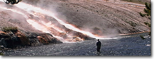
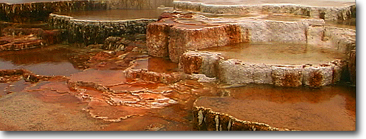
The influence of limestone in the Mammoth
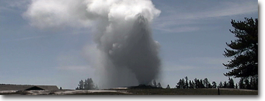
area also has changed the makeup of the hydrothermal features. Elsewhere
in the park, the surrounding rock is composed of silica dioxide, an
essential element in the formation of geysers. But, here, the presence
of calcium carbonate produces the unusual travertine terraces of Mammoth.
Osprey Falls Trail
Length: 1.0 miles, one way. Elevation
change: Trailhead at 7,000 feet (500-foot drop). Trailhead: Located
about three miles down the one way Bunsen Peak Road.
The trailhead for Osprey Falls is about
three miles down the narrow, dirt Bunsen Peak Road. The turn off for
this road is just above Rustic Falls and five miles south of Mammoth.
The small parking area is on the right side of the road and is not well-defined,
but should be marked. This area was burned extensively during the 1988
fires, and most of the Douglas firs-normally resistant to ground fires-burned.
This indicates it was a hot, fast-moving fire. It will take several
human lifetimes for this area to return to a mature Douglas fir forest.
The trail follows along the rim and descends
by way of switchbacks to the bottom of Sheepeater Canyon. This canyon
is an impressive 800-foot-deep gorge and ranks second only to the Grand
Canyon of the Yellowstone. During the descent, the columnar basalt forming
the Sheepeater Cliffs are visible across the canyon. These cliffs were
named by P.W. Norris in honor of the Sheepeater Indians, a band of the
Shoshone Indians, the only indigenous residents of the park who were
known for their use of cliffs to herd and kill game animals.The trail
ends at the base of Osprey Falls, which is hidden until then. Here,
the Gardner River plunges 151 feet and the canyon walls rise more than
500 feet in view. But the spray created
by this falls produces a cool, moist environment in contrast to the
descent on a hot summer day. Nonetheless, spring or early summer is
the best time to visit Osprey Falls-when the runoff is greatest.
Joffe Lake Trail
Length: 0.6 miles, one way.
Elevation change: Trailhead at 6,400 feet (80-foot gain).
Trailhead: Located at the south end of the Mammoth trailer/ maintenance
area. The turn off for this area is 1.3 miles south of the Mammoth Hotel,
past the lower terraces at the first hairpin curve.
The trail for this shallow lake begins
behind the Mammoth maintenance yard, on the south edge of the storage
and construction area. (The maintenance shed, built in the late 1980s,
is one of the largest buildings in Yellowstone.) This
lake is especially popular, providing an easy ski tour during the winter.
From the maintenance area, the lake is only 0.6 miles, and a small rise
hides the lake until a hiker or skier is upon it.
This small one-and-a-half-acre lake was
named in 1949 for Joseph Joffe (1896-1960). He was assistant superintendent
for the National Park Service, but was known to catch fish illegally
in the nearby Mammoth water-supply reservoir and claiming they were
caught in the "CCC Lake" (renamed Joffe Lake). One of the
lakes names came from the Civilian Conservation Corps (CCC), which had
its camp established in the trailer yard. Other names for this lake
include "Demonstration Pond," because fire equipment was demonstrated
here, and "Hoodo Lake," for the limestone formation above
the lake to the west. The mountain
to the south is Bunsen Peak (8,564 feet), named in honor of Robert Wilhelm
Eberhard von Bunsen (1811-1899). Bunsen originally pioneered the theory
of geyser function and has his name attached to the Bunsen Burner.
Clematis Gulch Trail
Length: 3.3 miles, loop. Elevation
change: Trailhead at 6239 feet (1221-foot, gain). Trailhead: Clematis
Gulch Trail is located near Liberty Cap and heads west up the gulch.
Clematis Gulch Trail is a short hike
that leads to trail access from Mammoth to Mammoth Beaver Ponds, Sepulcher
Mountain, Snow Pass, and the Upper Mammoth Terraces.
The first section of this trail is the
steepest and ascends about 350 feet in elevation through Douglas fir
in a shaded, cool, moist gulch. After about a quarter mile the trail
junctions with a trail accessing the Upper Mammoth Terraces to the south.
The Clematis Gulch loop trail returns to this point. After about half
a mile, the trail junctions with the Beaver Ponds Trail (see Mammoth
Beaver Ponds Trail for description).
The trail continues to follow Clematis
Creek for another half mile before junctioning again, this time with
Sepulcher Mountain Loop Trail (see Sepulcher Mountain Trail for description).
The north trail leads to Sepulcher Mountain and is the eastern half
of the Sepulcher Mountain Loop Trail. Whereas the south trail begins
a series of switchbacks and then junctions with the Snow Pass Trail.
The downhill, or eastern, trail returns to Mammoth. The trail skirts
the northern edge of the Upper Terraces and a side trip or a shortcut
to the trailhead goes through the thermal basin.
Old Stagecoach Rd
(formerly the Old Mammoth-Gardiner Road) Length: 3.6 miles, one
way. Elevation change: Trailhead
at 6,239 feet (759-foot loss). Trailhead: Directly behind the Mammoth
Hotel, is a dirt road cut into the hillside.
This old alternate stagecoach road brought
visitors to Mammoth from the railroad stop at Cinnabar, before the twisting
road that follows the Gardner River. It still is used today for vehicle
traffic, but seldom so. This old road is an excellent path for birding,
wildflowering, walking, mountain biking or winter ski-touring.
During summer, and especially in early
spring, this is one of the best birding areas in the park. You'll find
migratory songbirds, including Townsend's solitaire, waterpipit, finches,
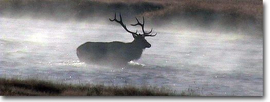
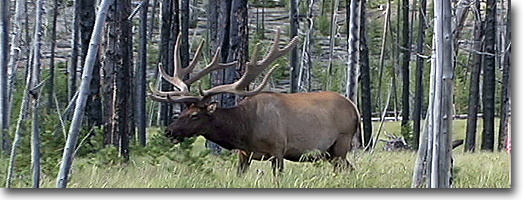
mountain bluebird, thrushes and sparrows, in the open terrain. While winter brings other wildlife, including
bighorn sheep that have migrated from their higher summer pastures,
mule deer, elk and antelope also are common along this road and trail. Most of this trail is open and exposed,
and the wind during spring and fall can be fierce. Rocky Mountain junipers,
Douglas firs and aspen are the primary trees found in the more protected
slopes and gullies.
To the east of the road, across the Gardner
River valley, is Mount Everts (7,841 feet). It was erroneously named
for Truman Everts, who became separated from his group and wandered
in the wilderness without his spectacles, horse or gear for 37 days
before being found in an emaciated state near Tower Creek, but F.V.
Hayden mistakenly named the creek just on the other side of this peak
Rescue Creek as the location of Truman's rescue. To the west lies Sepulcher
Mountain (9,652 feet) named by geologist Arnold Hague "on account
of its low black appearance." After
a short descent, the remaining distance is a gentle slope. The trail
emerges at the North Entrance! low the town of Gardiner
Beaver Ponds Trail
Length from Mammoth to: Beaver
Ponds 1.9 miles, one way. Beaver Pond Loop Trail 4.5 miles, loop. Elevation
change: Trailhead at 6,239 feet (560-foot gain). Trailhead: Clematis
Gulch Trail between Liberty Cap and the stone house at Mammoth.
The trail begins in Mammoth, between
Liberty Cap and the stone house, and follows a small, shaded creek up
Clematis Gulch. The first section of this hike is the steepest and ascends
some 350 feet through Engelmann spruce and Douglas fir trees. The trail
then splits, and the west trail heads toward Sepulcher Mountain. For
the beaver ponds, continue north (right) and about two miles from the
trailhead are a series of step-like beaver-created ponds along the stream.
As beaver are mainly nocturnal animals, your best chances to see one
are at dawn or dusk. After the
beaver ponds and the return trip to Mammoth, the vegetation and views
change. Quaking aspen trees are intermingled among sagebrush, and the
vista of the Absaroka Range is to the north. The trail eventually parallels
and joins the old Mammoth-Gardiner road, terminating behind the Mammoth
hotel.
Lava Creek Trail
Length to: Undine Falls 0.5
miles, one way Confluence with Gardner River 2.5 miles, one way Mammoth
School/footbridge 3.5 miles, one way Elevation change: Trailhead at
6,560 feet (760-foot drop). Trailhead: The trailhead is just less than
5 miles east of Mammoth, on the Mammoth-Tower Road at the Lava Creek
bridge and picnic area.
The Lava Creek Trail is a one-way trail
following Lava Creek and Gardner (note the different spelling from the
town of Gardiner) River drainages. You can begin on the trail from either
end; for a downhill hike, start at Lava Creek picnic area. The picnic
area and parking is at the pull off near the Lava Creek bridge. But
the trailhead is to the north, across the highway and on the east side
of the bridge and creek.
From the bridge, the trail follows Lava
Creek among Douglas firs and then begins a steep descent into Lava Creek
Canyon. At the start of the canyon. Lava Creek plunges over a double
waterfall. The upper terrace is 60 feet high and the lower one is 50
feet high. The Hague party named Undine (pronounced Un-deen) Falls in
1885 for mythical water nymphs who, in folklore, live around waterfalls
and acquire mortal men's souls by marrying them and bearing their children.
The trail continues down the canyon along
open, exposed slopes, following Lava Creek until it merges with the
Gardner River. This section of the river is less tumultuous than it
is upstream. Springs and seeps line the shore, and beaver have taken
up residency here. Mount Everts is the steep. Rocky Mountain juniper
sloped mountain rising from the river to the east. During winter and
early spring bighorn sheep can often be spotted traversing the steep
slope. The hike ends at the footbridge crossing the Gardner River, and the trail emerges behind the Mammoth
Elementary School. There also is a service road leading to the bridge
but it is easily accessed by foot from the Mammoth campground, which
is across the highway from the school.
Rescue Creek Trail
Length from Blacktail Trailhead to: Blacktail
Deer Creek Trail junction North Entrance Trailhead
(suspension bridge) 7.0 miles, one way. Elevation change: Trailhead
at 6,640 feet (1,280-foot loss, but 1,520-foot loss overall).
Trailhead: Rescue Creek Trail can be
approached from two directions: the North Entrance trailhead or the
Blacktail Deer Creek Trailhead. The Blacktail Trailhead, located 6.6
miles east of the Mammoth Hotel on the Mammoth-Tower Road, provides
a downhill direction. The North Entrance trailhead is located about
a half mile south of the entrance station.
Rescue Creek was erroneously named for
the rescue site of Truman Everts, who became separated from his group
and wandered in the wilderness without his spectacles, horse or gear
and lived on the roots of elk thistle for 37 days before being rescued.
His rescue location, however, was near Tower Creek, but F.V. Hayden
mistakenly named this as the location
and it has borne the name Rescue Creek ever since.
The Rescue Creek Trail is a popular spring
or early summer hike because it generally is snow-free before other
park trails. Also in spring, pink bitterroots, the Montana state flower,
cover the small, windswept ridges just beyond the parking area. The trail begins in open sagebrush country
and soon junctions from Blacktail Deer Creek Trail (see Blacktail Deer
Creek Trail for description) where Rescue Creek Trail heads west up
Rescue Creek. From here, the trail climbs gradually through aspens and
open meadows. Several small ponds or kettle lakes, left by retreating
glaciers, provide habitat for migrating waterfowl. In spring, ruddy
ducks frequently use these ponds on their northern migration.
The trail then begins a steep descent
of nearly 1500 feet to the Gardner River. Rattlesnake Butte, to the
north, blocks the view of the Yellowstone River. At the river is the
lowest elevation in the park, and occasionally western rattlesnakes
and bull snakes are found along this region. The trail then skirts the
northern base of Mount Everts before crossing the Gardner River via
a well-built foot and horse bridge. The
northern section of the Rescue Creek Trail, along the lower slope of
Mount Everts, is one of the best hikes for viewing wildlife early in
spring, or late in fall (October-November). Elk, mule deer, antelope
and bighorn sheep winter in this region. As a result, wintering elk
and deer shed their antlers on the open meadow. This trail, traditionally,
has been used as a corridor for elk-antler poachers, locally called
horn hunters.
|