GIacial
times never seem far away in the Greater Yellowstone Ecosystem. If you
were to walk the streets of Chicago on a hot August day, you would have
a rough time believing that 150 centuries ago the land beneath the sidewalk
was covered by ice thousands of feet thick. In Grand Teton National
Park, on the same August day, you can view a glacier. From the valley
floor, the Teton Glacier is only 4.5 miles to the west and 7,000 feet
up the mountain. More glaciers grace the flanks of nearby Mt. Moran.
On the Pitchstone Plateau of Yellow-stone,
a hiker in August can find patches of last winter's snow in the shade
of obsidian ledges, if they aren't already covered
by the new snows of autumn. The mean annual temperature at Lake Ranger
Station in Yellowstone is 33° F, just a tad above freezing. Possibly
the most striking examples of Yellowstone's deep chill are Yellowstone
and Lewis lakes that remain frozen most years from December to late
May. Often Lewis Lake melts in early June.
|
"The Wonders
of Yellowstone"
- 98 Minutes
-
~Telly Award Winner for Nature
and Wildlife~
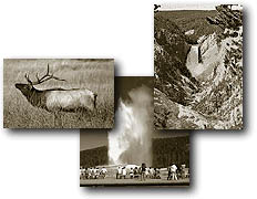
Two years in the making
and just released, "The Wonders of Yellowstone" video
has been highly requested, produced in DVD format and is now available.
Take a complete tour of Yellowstone National Park as our Narrator
Cathy Coan guides you to all the wonders of the park including
all the geyser basins, wildlife, waterfalls and much more.
We previously sold
travel packets but these packets, maps and trail guides are all
available at the park for free or minimal charge.
More
Info or Order Online |
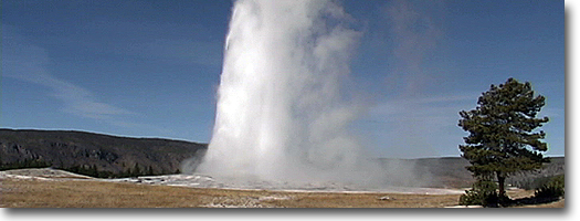
Winter weather in northwest Wyoming is
brisk. Temperatures around -40° F routinely occur at Old Faithful, and
those in the town of Jackson, Wyoming, are often below -30° E With these
temperatures in mind, it is not difficult to imagine the effect colder,
more cloudy summers and temperature drops of perhaps 15° F might
have on the Greater Yellowstone Ecosystem.
In this chapter we will look in detail
at Yellowstone's youngest glaciation, the Pinedale, and make some general
observa tions about its predecessor, the Bull Lake Though there were
eight or more earlier glaciations than Bull Lake in the Yellowstone
region, we know little about them. We will follow the growth of the
Pinedale glaciers in Yellowstone and Grand Teton national parks and
their immediate environs. We will look at land-forms and deposits the
glaciers left behind, and try to explain how these landforms and deposits
were formed. !
But before we look at the details, try
to imagine what Yellowstone and Grand Teton national parks looked like
on a summer day 25,000 years ago at the height of Pinedale glaciation.
The Yellowstone ice field at that time was near its maximum size. Imagine
you are standing at the Snake River Overlook in Grand Teton, facing
north. Immediately in front of you is a wall of ice that extends from
the eastern valley wall nearly to the Tetons. Streams of muddy water
pour down the glacier's blue face and flow from tunnels at its base.
Occasional boulders tumble from the ice face amid a constant cascade
of gravel. Muddy meltwater, gravel, and boulders enter a wide, shallow
river heading two miles east near the present-day Lost Creek Ranch,
between Shadow Mountain and the glacier before you. Braided channels
of this river move constantly across a treeless plain, shifting from
south to west and back again as they construct a huge alluvial fan of
glacial debris. Although it is mid-summer, a cool breeze drifts down
the glacier's face.
To the west, the ice-sheathed peaks of
the Teton Range tower above great rivers of ice filling the canyons
and spilling out onto the plain. Sagebrush and tundra grasses hug the
treeless slopes and foothills around you; dwarf willows border restless
streams. Far to the south-west, you see clumps of trees in protected
areas.
If you stood here at the Snake River
Overlook on a stormy September day, you might have trouble standing
at all. The cool summer breeze is now a blustery chill blast. The muddy
streams of summer have shrunk to trickles-many, in fact, are empty,
their dried-out channels caked with silt and mud. The fierce winds of
autumn whip the dry sediments into rolling clouds which, carried south,
fall as blankets of windblown dust called loess. Today, on high terraces
south of Jackson, deposited during the last glaciation, loess is as
much as 20 feet thick.
Now back to summer and a major adventure:
We decide to explore the huge ice field to the north. We pick a route
up its sloping face and begin the difficult climb up the glacier's back.
At first the slope is steep (more than 500 feet/mile), but soon it flattens
to less than 100 feet/mile then becomes nearly horizontal.
To the east a vast sea of featureless
ice is punctuated by the isolated peaks of Whetstone and Gravel mountains.
To the west stands the Teton Range high above the Snake River valley.
The ice sheet beneath us extends westward nearly to the base of the
Tetons. The Snake River valley to the north is ice-free for miles, but
at its northern end is a lobe of Yellowstone ice filling it from wall
to wall. Between the lobe of Yellowstone ice advancing down the Snake
River Valley and the lobe we are standing on is an ancient Jackson Lake
whose gray-green waters are dotted with icebergs calved from valley
glaciers pouring out of the Tetons.
As we continue our trek, and as the air
chills, we notice that runoff on the glacier's surface is becoming less
and less. At about 9,000 feet elevation, the bare ice gives way to slush,
then old dry snow. We have reached snowline on the glacier. Up, up,
day after day, we finally cross the southern boundary of Yellowstone.
Behind us are the Teton peaks. Ahead on our left the summit of Mt. Sheridan
lies a few hundred feet beneath the ice. On our right, a chain of dark
knobs barely piercing an expanse of white marks the crest-line of the
Absaroka Range.
As we approach the vicinity of present-day
Yellowstone Lake, the ice underfoot is about 4,000 feet thick. In every
direction, to the very horizons, a boundless, unrelieved plain of snow-covered
ice lies silent and lifeless under a glaring sun. We have reached the
summit of the Yellowstone ice field.
On the flat, nearly featureless icescape
we follow a compass course north. We pause above
the buried crest of the Washbum range reflected by broad, subtle mounds
in the nearly horizontal surface of the ice. Far to the northeast, a
mighty dome of snow and ice mantles the granite massif of the Beartooth
Mountains. To the northwest are the nearby peaks of the Gallatins and
the faraway peaks of the Madison Range. To the south bulks the broad
summit dome of the ice field.
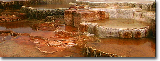
We cross ice-buried hot springs, progenitors
of the Mammoth Terraces, about three thousand feet beneath our boots.
Just beyond to the north, the gentle slope of the Yellowstone valley
glacier steepens and curves below Yankee Jim Canyon . Eventually we
make our way through the crevasses down to the terminal ice face near
Chico Hot Springs in Montana. Our traverse from the Snake River Overlook
across the buried Washbum Range has taken us across an ice divide at
an altitude of about 11,500 feet. We have covered a distance of about
120 miles in a 10-day journey on trackless ice. From Chico Hot Springs,
could we have seen the southern margin of the great continental ice
sheet to the north? No, we would have had to trudge another 150 miles
north across windy, cold, sparsely vegetated plains to the vicinity
of Great Falls, Montana, to reach the edge of that ice mass.
|