|
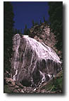
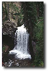
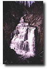
CAVE FALLS
(On-trail, w/ road access)
This waterfall of the
Falls River in the southwest corner of the park is only twenty feet high, but its spectacularity rests in the fact that it
is 250 feet wide. It is probably the park's widest waterfall.
It has an immediate upper step that is about three feet high
and a lower step about 100 yards downstream that is around five
feet high.
Cave Falls is
accessible by road from Ashton, Idaho and is quite popular with
local Idaho residents. It is the starting point for many hikes
in the Bechler Region as several trailheads are located here.
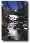
 TERRACED
FALLS (on-trail) TERRACED
FALLS (on-trail)
Terraced Falls is perhaps
the most striking waterfall of the entire Falls River. It is
composed of six falls, which all together total about 140 feet.
Members of the 1872 Hayden survey wrote of five falls here but
geologist Walter Weed noted six in 1886 with heights of 35,
25, 50, 5, 10, and 5 feet respectively.
Terraced Falls
is easily accessible via the Terraced Falls Trail from the Reclamation
(Ashton-Flagg Ranch) Road along the park's south boundary. In
two miles the trail passes six other small falls and cascades
and we recommend it highly for anyone who wants an introductory
taste of the Yellowstone backcountry.
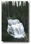
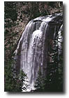
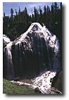 UNION
FALLS (on-trail) UNION
FALLS (on-trail)
This breathtakingly
beautiful falls is one of Yellowstone's tallest at 250 feet
and is one of the most frequently named candidates for "most
beautiful" of Yellowstone's waterfalls. Formed by the union
of Mountain Ash Creek and an unnamed branch, it was named during
the period 1884-86 by members of the Hague parties of the U.S.
Geological Survey. It is
a massive, imposing, and gorgeous waterfall.
It is geologically
unique in appearance with its twin streams falling mightily
over its sheer face of rock. It ranks as one of the most popular
employee day hikes in the entire park. Trailheads at Grassy
Lake, Fish Lake, and Cave Falls will all lead to the falls.
The shortest is the Grassy Lake trailhead with a round-trip
of nearly 15 miles. It should be noted that this route is also
the most strenuous with at least one large ridge to climb on
the return trip. Consult any park trail guide for more information
on this extremely worthwhile and memorable hike.
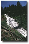
MORNING FALLS
(off-trail)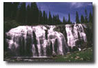
One of the more recent
waterfall discoveries of the Yellowstone backcountry is a stunning,
sixty-foot falls located on the unnamed north fork of Mountain
Ash Creek about two miles northwest of Union Falls. In addition
its stature is further enhanced by its one hundred-foot width.
The name was suggested in 1976 by guidebook writer Tom Carter
from the fact that the falls faces southeast, while the rest
of the stream faces southwest, and hence catches the rays of
the morning sun.
 OUZEL
FALLS (off-trail - to view up close) OUZEL
FALLS (off-trail - to view up close)
Often touted as one
of Yellowstone's tallest waterfalls, this elegant waterfall
is 230 feet high and is located on the lower stretch of Ouzel
Creek. It was named in 1885 by the Hague Survey for the water
ouzel or American dipper, a small slate-gray bird which feeds
underwater by diving and walking along the bottoms of streams.
Ouzel Falls is best observed in the early season as it loses
a great deal of its water towards the latter part of August.
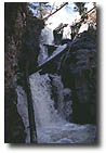
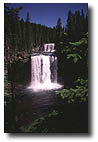 COLONNADE
FALLS (on-trail) COLONNADE
FALLS (on-trail)
This double-plunge
of the Bechler River was named in 1885 by members of the Hague
Survey. A colonnade is a series or row of columns placed at
regular intervals, or a double row or avenue (as of trees).
The reason for the name is undocumented, but it probably referred
either to the nearby columnar basalt layers which resemble columns
or to the fact that there were two waterfalls, or perhaps to
both. The upper falls is 35 feet tall while the lower is 67
feet.
 IRIS
FALLS (on-trail) IRIS
FALLS (on-trail)
A 45-foot-high falls
of the Bechler River, Iris Falls was named either for its irised
spray which often creates a rainbow here or for Iris, a Greek
and Roman female goddess of the rainbow. Regardless, rainbows
seem to have been forefront in the thinking of Hague Survey
members who named it in 1885.
 ALBRIGHT
FALLS (on-trail) ALBRIGHT
FALLS (on-trail)
Albright Falls, a 260-foot
sloping cascade on an unnamed southerly tributary of the Bechler
River, was named in 1986 by park superintendent Bob Barbee following
the death of Horace Marden Albright. Albright helped to found
the National Park Service in 1916, served as Yellowstone's superintendent
for the decade 1919-1929, and was an advisor and mentor to the
Park Service for the rest of his life.
Albright Falls
can be readily seen from the Bechler River Trail. Unfortunately,
trees today obscure some parts of its whitewater cascade from
nearly every angle.
RAGGED FALLS
(on-trail)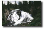
Ragged Falls is located
on the Ferris Fork of the Bechler River about 200 yards above
Three River Junction. Characteristically named because of its
ragged appearance, this 45-foot waterfall was named in 1921
by park photographer Jack Haynes.
This falls is easily seen from
the Bechler River trail, which passes next to its brink. However
the superior viewpoint is from the opposite (eastern) side of
the stream.
 TENDOY
FALLS (off-trail) TENDOY
FALLS (off-trail)
Tendoy Falls, located
on Ferris Fork of the Bechler River, is thirty-three feet high.
W. C. Gregg and Jack Haynes named it in 1921 for Tendoy, a chief
of the Lemhi Shoshones, who lived near Yellowstone National Park
in eastern Idaho.
This waterfall is
quite pleasing. It is set between gray, 40-foot cliffs that line
both sides of the creek for some distance downstream.
 WAHHI
FALLS (off-trail) WAHHI
FALLS (off-trail)
This two-step waterfall on the Ferris Fork of the Bechler
River has heights of 28 feet (upper) and 18 feet (lower). The
name Wahhi Falls comes from a Shoshone Indian term (wahat hwa)
meaning "two step" or "double." The falls
themselves are both plunges.
TWISTER FALLS
(on-trail)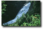
There has long been
confusion between this falls on the Gregg Fork of the Bechler
River and another one a short distance upstream. Many recent
maps show the name Twister on the wrong feature. The true Twister
Falls as mapped in 1921 and named by explorer W.C. Gregg that
year is three-quarters of a mile downstream from the other,
and closer to the mouth of Littles Fork. This original Twister
Falls makes a characteristic twist as the water drops and has
a height of 55 feet.
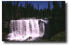
 DUNANDA
FALLS (on-trail) DUNANDA
FALLS (on-trail)
This exquisite falls,
located on Boundary Creek, is 150 feet high. A plunge-type falls,
it has always been credited with discovery in 1920 by explorer
W.C. Gregg. It is a nine mile hike from the Bechler Ranger Station
and and is a very popular backcountry hike. It also has the distinction
of gracing the cover of this book.
 SILVER
SCARF FALLS (on-trail) SILVER
SCARF FALLS (on-trail)
Located only one-quarter
mile east of Dunanda Falls, Silver Scarf Falls is on an unnamed
branch of Boundary Creek which hikers must cross three times
on the trail from Bechler Ranger Station before reaching the
falls itself. This falls is only two hundred yards southeast
of Dunanda Falls.
The unnamed stream
on which Silver Scarf Falls is located originates many miles
north in a large, open valley containing massive number of unmapped,
unnamed thermal springs there which contribute to the water
of this warm stream.
 FERN
CASCADES (on-trail) FERN
CASCADES (on-trail)
A series of cascades
on Iron Spring Creek can be viewed only a few short miles southwest
of Old Faithful Geyser. Its name, Fern Cascades, is characteristic
of the luxuriant ferns which grow in this moist area. The feature
is a three-step cascade with drops of 10 feet, 20 feet, and
70 feet.
Portions of this
lengthy stretch of whitewater can be seen from the Fern Cascades
Loop Trail. Unfortunately good views are only available of the
10 and 20-foot sections.
 MYSTIC
FALLS (on-trail) MYSTIC
FALLS (on-trail)
Located on the Little
Firehole River, Mystic Falls has a height of about seventy feet.
Originally called "Little Firehole Falls" by the 1872
Hayden survey, its present name, given in 1885, is probably
merely fanciful and imaginative. It has long been a favorite
short hike of Old Faithful area visitors and employees, and
1930s visitors often swam at its base.
The short trip
to Mystic Falls is one of the most popular hikes in Yellowstone.
An easy well-maintained trail leaves the boardwalk at the far
end of Biscuit Basin and winds through lodgepole pines for a
short mile before reaching the falls.
 FAIRY
FALLS (on-trail) FAIRY
FALLS (on-trail)
Located on Fairy Creek
south of Twin Buttes, Fairy Falls plunges 197-feet from the
Madison Plateau. Captain J.W. Barlow named it in 1871.
The two-mile
hike to Fairy Falls is another of the park's more popular. An
inviting plunge-pool at its bottom seems to beckon to bathers,
although the water is usually quite cold.
 SILVER
CORD CASCADE (on-trail) SILVER
CORD CASCADE (on-trail)
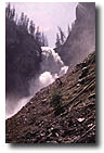
Perhaps Yellowstone's
tallest waterfall, this extremely high waterfall (or series
of steep cascades) plummets some 1200 feet. It is located on
Surface Creek at the point that stream enters the Grand Canyon
of the Yellowstone from the south. Hikers can view it from the
Glacial Boulder Trail near Inspiration Point, roughly one mile
east of Glacial Boulder. If one is so inclined, the Ribbon Lake
Trail leads to the brink of this falls, but here much caution
must be used.
 OSPREY
FALLS (on-trail) OSPREY
FALLS (on-trail)
This 150-foot waterfall
of the Gardner River was named in 1885 by members of the Hague
parties of the U.S.G.S. for the osprey or fishhawk which frequents
Yellowstone Park. Although it is on a major park stream, hikers
only occasionally visit it. It can be reached via the Osprey
Falls trail, which is accessed by the Bunsen Peak loop drive
(no longer open to motor vehicles but available for bicycles
and foot travel). Hikers should be aware that this is a steep
trail with many switchbacks as it descends over 700 feet into
the heart of Sheepeater Canyon.
 HIDDEN
FALLS (on-trail) HIDDEN
FALLS (on-trail)
Nameless for many years
and appearing on maps only as "falls," this twenty-foot
falls was first documented by Captain John Barlow in 1871. Over
100 years later the falls reappeared under the name "Hidden
Falls" in the 1984 publication Ribbons of Water. It is
easy to miss this falls even though it is only a short distance
from the Blacktail-Yellowstone River trail.
 PLATEAU
FALLS (off-trail) PLATEAU
FALLS (off-trail)
This extremely remote,
80-foot waterfall of Plateau Creek was named around 1896 by
members of the Hague parties of the U.S.G.S. It can be found
high on the Two Ocean Plateau in the park's Thorofare region,
making it Yellowstone's most distant, officially named waterfall.
It takes a minimum of three days just to hike to this distant
and rarely visited locale.
|